Computer Modelling

|
|
North Queens TV White Space Trials Computer Modelling
|
|
|
|
||
|
We have had several enquiries as to how we do the computer modeling throughout the site and therefore thought it might be useful to explain the process. We use a program called Radio Mobile developed by amateur radio operator VE2DBE. Radio Mobile is dedicated to amateur and humanitarian uses and is free for non commercial and commercial use on a no liability basis. It is based on the Longley-Rice propagation model and well regarded in amateur and professional circles.
It is perhaps easier if a first time user has some GIS mapping and radio propagation background although the are several excellent and detailed tutorials online this is the one we used to get started
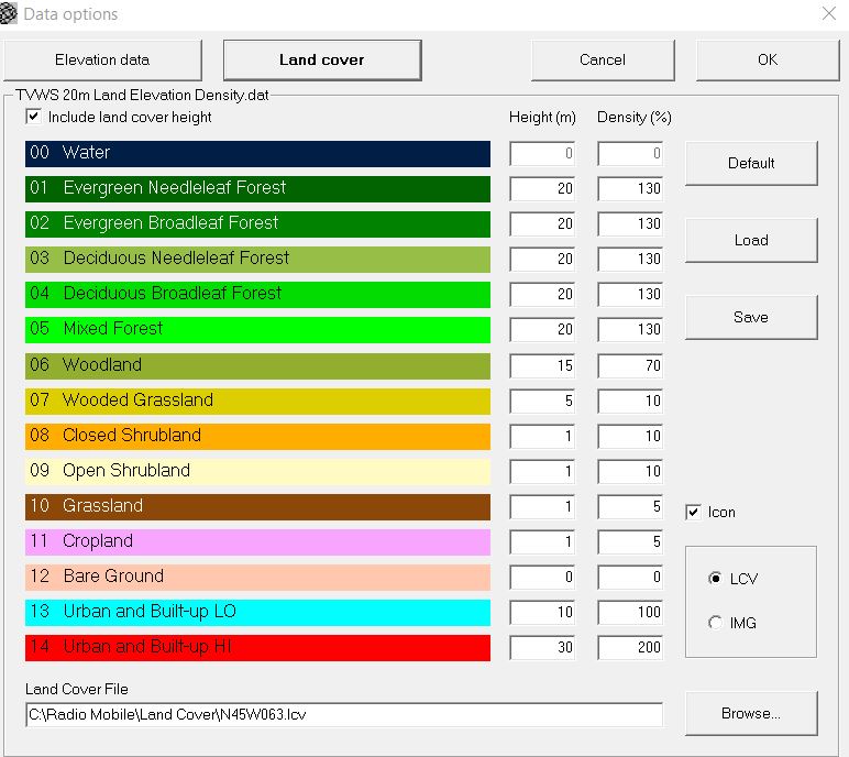
One of features in Radio Mobile is the ability to use satellite based vegetation data a feature lacking in many commercial programs and nearly all online products, without this our modelling would be too inaccurate to be of any use.
The are some limitation with the current satellite data in that in only identifies the type of vegetation coverage and not it's height or density, Radio Mobile comes with some default values but I'm guessing they are from another part of the world with a considerably different idea of what constitutes tree coverage. Fortunately it is possible to enter your own correction values. One of the main purposes of these trials was to help improve our computer modeling and determine suitable corrections. These are the corrections we finally decided to use and are the ones used in all the computer modeling in this website, you can look at the actually results to see how accurate we were.
These settings can be found in Radio Mobile under:- options - Elevation data - Land cover
Although Radio Mobile will save and display your results in a number of ways including TIFF, PNG, JPEG and others we prefer to use Google Earth particularly for things such as coverage maps. Naturally there are some handy online tutorials explaining the process.
Saving Coverage Maps to Google Earth Saving link path to Google Earth
|
||